Land cover and land use: Difference between revisions
Jump to navigation
Jump to search
m (Text replace - "|Status=On hold" to "") |
No edit summary |
||
| Line 1: | Line 1: | ||
{{ComponentTemplate2 | {{ComponentTemplate2 | ||
|InputVar=Crop and grass fractions; Grassland, agricultural, and abandoned area; Potential natural vegetation; | |||
|OutputVar=Land cover; Land for bioenergy; Land supply; | |||
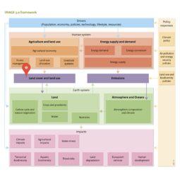
|Description=<h2>Interaction between the human system and environmental system: land allocation and emissions</h2> | |||
There are several ways by which the human system directly influences the earth system. Land allocation and [[Emissions|atmospheric emissions]] form two of the most important factors, others include water extraction, and water and soil pollution. | |||
===Land allocation=== | |||
Using the demand for land to produce agricultural food products and bio-energy, the Land Allocation model determines at a 5 min x 5 min grid where this production occurs using a set of allocation rules. For instance, grid cells with a high potential to produce agricultural products (in terms of climate, soil types), that are near water (for transport and irrigation) and near to existing urban or agricultural areas are considered to be most suitable for agricultural production. In the model these rules in combination with regional preferences for different types of production systems, determined from historical calibration, are used to allocated land use to the grid. | |||
As observed in other baseline scenarios, in the [[Rio+20]] baseline the expansion of agricultural production in tropical regions leads to a loss of natural ecosystems, and an associated loss of biodiversity. In fact, most of the expansion is projected to occur in highly productive ecosystems near existing agricultural areas, thus including tropical forests and woodland, other high nature value savanna and grassland area. At the same time, in the temperate zones there is actually a contraction of the agricultural area. Here, the grid cells least suitable for production potential are abandoned. The resulting changes in agricultural area are depicted in [[Figure 2.5**]]. | |||
|ComponentCode=LCU | |ComponentCode=LCU | ||
|FrameworkElementType=state component | |||
|FrameworkElementType=state component | |||
}} | }} | ||
Revision as of 15:01, 28 January 2014
| Component is implemented in: |
| Components: |
| Projects/Applications |
| Key publications |
| References |