Crops and grass: Difference between revisions
Jump to navigation
Jump to search
No edit summary |
No edit summary |
||
| Line 1: | Line 1: | ||
{{ComponentTemplate2 | {{ComponentTemplate2 | ||
|IMAGEComponent=Carbon, vegetation, agriculture and water; Land-use allocation; Atmospheric composition and climate; | |||
|KeyReference=Bondeau et al., 2007; Waha et al., 2012; | |KeyReference=Bondeau et al., 2007; Waha et al., 2012; | ||
|Reference=IPCC, 2007a; | |||
|InputVar=Temperature - grid; Precipitation - grid; Number of wet days - grid; Cloudiness - grid; CO2 concentration; Land cover, land use - grid; Change in soil properties - grid; Management intensity crops; Number of wet days - grid; Cloudiness - grid; Irrigation water supply - grid; | |InputVar=Temperature - grid; Precipitation - grid; Number of wet days - grid; Cloudiness - grid; CO2 concentration; Land cover, land use - grid; Change in soil properties - grid; Management intensity crops; Number of wet days - grid; Cloudiness - grid; Irrigation water supply - grid; | ||
|Parameter=Residue management; Soil properties - grid; | |Parameter=Residue management; Soil properties - grid; | ||
|OutputVar=Potential crop and grass yield - grid; Crop irrigation water demand - grid; Potential bioenergy yield - grid; Actual crop and grass production - grid; Rainwater consumption - grid; Irrigation water consumption - grid; | |OutputVar=Potential crop and grass yield - grid; Crop irrigation water demand - grid; Potential bioenergy yield - grid; Actual crop and grass production - grid; Rainwater consumption - grid; Irrigation water consumption - grid; | ||
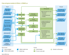
|Description=model | |Description=World population and per capita consumption of agricultural products are projected to increase substantially, which will require a significant increase in agricultural production. Currently, over one third of the Earth’s land area is under agricultural production, which is already about half the area suitable for agriculture. Pasture covers 68% of the global agricultural area, and cropland covers 32%. Agricultural production can be increased by expanding the agricultural area (more hectares) and by intensification (higher output per hectare). | ||
However, the extent and distribution of agricultural land affects the Earth system, because agricultural systems are closely linked with natural ecosystems, human societies and the climate system. Agricultural land differs significantly from natural ecosystems in biogeochemical (e.g., carbon, water, nutrients) and bio-geophysical (e.g., albedo, energy balance) properties. Current land-use patterns have a significant impact on climate ([[Pitman et al., 2009]]; [[Strengers et al., 2010]]), and climate directly affects agricultural productivity ([[Müller et al., 2009]]; [[Rosenzweig et al., 2013]]). A large proportion of anthropogenic greenhouse gas emissions is caused by agricultural production, mediated by management and associated land-use dynamics ([[IPCC, 2007a]]). | |||
Crop growth models are used to assess future area requirements, spatial patterns of agricultural production, and available areas for biomass-based energy (bioenergy). IMAGE 3.0 uses the [[Carbon, vegetation, agriculture and water|LPJmL model]] on dynamic global vegetation, agriculture and hydrology ([[Bondeau et al., 2007]]; [[Fader et al., 2010]]; [[Waha et al., 2012]]). This model dynamically simulates plant growth, agricultural productivity, and the carbon and water dynamics of agricultural land with detailed processes of photosynthesis, respiration, growth and phenology. In the model’s current form, management intensity can be approximated per crop type on national scale ([[Fader et al., 2010]]). Irrigation patterns are obtained from the Land-use allocation model of IMAGE (Component [[Land-use allocation]]), and other management options are calculated internally, such as sowing dates, selection of crop varieties and the demand for irrigation water. | |||
LPJmL simulates yields per crop under optimal management intensities for each grid cell and irrigation system as well as irrigation water requirements, which is input to the IMAGE Land-use allocation model (Component [[Land-use allocation]]) for simulations of land-use change dynamics. Climate change calculated by the IMAGE climate model (Component [[Atmospheric composition and climate]]) directly affects future agricultural productivity because these components are dynamically linked in annual time-steps. | |||
|ComponentCode=CG | |ComponentCode=CG | ||
|AggregatedComponent=Carbon, vegetation, agriculture and water | |AggregatedComponent=Carbon, vegetation, agriculture and water | ||
|FrameworkElementType=state component | |FrameworkElementType=state component | ||
}} | }} | ||
Revision as of 12:00, 20 May 2014
Parts of Crops and grass
| Component is implemented in: |
|
| Related IMAGE components |
| Projects/Applications |
| Key publications |
| References |
Key policy issues
- How will climate change affect the productivity of current and future agricultural areas?
- How could management improve agricultural productivity under current and future water constraints?
- How will agriculture affect the Earth system with respect to carbon emissions, freshwater availability and nutrient cycles?