Land degradation/Description: Difference between revisions
Jump to navigation
Jump to search
No edit summary |
No edit summary |
||
| Line 2: | Line 2: | ||
|Reference=Oldeman et al., 1991; Batjes, 1997; Harris et al., 2013; | |Reference=Oldeman et al., 1991; Batjes, 1997; Harris et al., 2013; | ||
|Description=Water erosion is the main cause of land degradation (1049 million hectares (Mha), followed by wind erosion (548 Mha), chemical degradation (239 Mha) and physical degradation (83 Mha) (GLASOD; [[Oldeman et al., 1991|Oldeman et al. (1991)]]). IMAGE assesses soil erosion by water ([[Hootsmans et al., 2001]]) by calculating a water erosion sensitivity index, ranging from zero (no erosion risk) to one (extremely high erosion risk). This risk is calculated for each grid cell as the compounded result from the following indices: | |Description=Water erosion is the main cause of land degradation (1049 million hectares (Mha), followed by wind erosion (548 Mha), chemical degradation (239 Mha) and physical degradation (83 Mha) (GLASOD; [[Oldeman et al., 1991|Oldeman et al. (1991)]]). IMAGE assesses soil erosion by water ([[Hootsmans et al., 2001]]) by calculating a water erosion sensitivity index, ranging from zero (no erosion risk) to one (extremely high erosion risk). This risk is calculated for each grid cell as the compounded result from the following indices: | ||
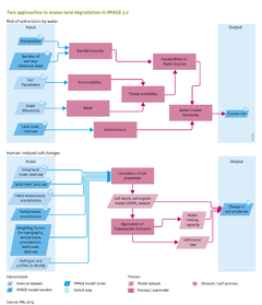
==A. Risk of soil erosion caused by water== | |||
Water erosion is the main cause of land degradation (1049 million hectares (Mha), followed by wind erosion (548 Mha), chemical degradation (239 Mha) and physical degradation (83 Mha) (GLASOD; [[Oldeman et al., 1991|Oldeman et al. (1991)]]). IMAGE assesses soil erosion by water ([[Hootsmans et al., 2001]]) by calculating a water erosion sensitivity index, ranging from zero (no erosion risk) to one (extremely high erosion risk). This risk is calculated for each grid cell as the compounded result from the following indices: | |||
* ''terrain erodibility index'': terrain erodibility represents the water erosion characteristics of the terrain in an index that combines surface relief and soil properties, expressed as index numbers. The relief index is a landform characteristic derived from a digital elevation model, calculated from the difference between minimum and maximum altitude in a 10 minute grid cell. The index is 1 for a difference of 300 m or more and zero for no altitude differences, with a linear relationship assumed between the two extremes. The soil erodibility index is derived from indices on soil texture, bulk density and soil depth. Soil characteristics were deduced from the 0.5x0.5 degree resolution in the [[WISE database]] ([[Batjes, 1997]]). | * ''terrain erodibility index'': terrain erodibility represents the water erosion characteristics of the terrain in an index that combines surface relief and soil properties, expressed as index numbers. The relief index is a landform characteristic derived from a digital elevation model, calculated from the difference between minimum and maximum altitude in a 10 minute grid cell. The index is 1 for a difference of 300 m or more and zero for no altitude differences, with a linear relationship assumed between the two extremes. The soil erodibility index is derived from indices on soil texture, bulk density and soil depth. Soil characteristics were deduced from the 0.5x0.5 degree resolution in the [[WISE database]] ([[Batjes, 1997]]). | ||
| Line 10: | Line 12: | ||
All intermediate and resulting factors are expressed as dimensionless indices from zero to one, and so too is the end indicator, Water Erosion Sensitivity Index. | All intermediate and resulting factors are expressed as dimensionless indices from zero to one, and so too is the end indicator, Water Erosion Sensitivity Index. | ||
===susceptibility and sensitivity indices=== | |||
The susceptibility and sensitivity indices are calculated according to: | |||
<pre> | |||
T = (Ia+ SE)/2 | |||
Ep = (T+R)/2 | |||
WES = Ep•V | |||
with: | |||
* Ia = relief index (-) | |||
* SE = soil erodibility index (-) | |||
* T = terrain erodibility index (-) | |||
* R = rainfall erosivity index (-) | |||
* Ep = water erosion susceptibility index (-) | |||
* V = land-use/land-cover index (-) | |||
* WES = Water Erosion Sensitivity Index (-) | |||
</pre> | |||
}} | }} | ||
Revision as of 12:25, 18 May 2014
Parts of Land degradation/Description
| Component is implemented in: |
|
| Related IMAGE components |
| Projects/Applications |
| Models/Databases |
| Key publications |
| References |