Land-use allocation/Description: Difference between revisions
Jump to navigation
Jump to search
No edit summary |
No edit summary |
||
| Line 1: | Line 1: | ||
{{ComponentDescriptionTemplate | {{ComponentDescriptionTemplate | ||
|Reference=Van Asselen and Verburg, 2013; Alexandratos and Bruinsma, 2012; Klein Goldewijk et al., 2010; O'Neill, 2013; Lambin et al., 2000; IIASA and FAO, 2012; Nelson, 2008; Klein Goldewijk et al., 2011; Letourneau et al., 2012; Doelman et al., in preparation; | |Reference=Van Asselen and Verburg, 2013; Alexandratos and Bruinsma, 2012; Klein Goldewijk et al., 2010; O'Neill, 2013; Lambin et al., 2000; IIASA and FAO, 2012; Nelson, 2008; Klein Goldewijk et al., 2011; Letourneau et al., 2012; Doelman et al., in preparation; | ||
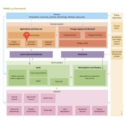
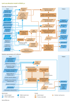
|Description=IMAGE 3.0 uses a regression-based suitability assessment to determine future land-use patterns. Optionally, the IMAGE allocation module can be coupled to CLUMondo ([[Van Asselen and Verburg, 2013]]) | |Description=IMAGE 3.0 uses a regression-based suitability assessment to determine future land-use patterns. Optionally, the IMAGE allocation module can be coupled to CLUMondo ([[Van Asselen and Verburg, 2013]]) providing a more detailed representation of land-use systems and their dynamics. | ||
Land-use allocation is driven by regional crop and grassland production and their respective intensity levels, as calculated by the IMAGE agro-economic model ([[Agricultural economy]]). Agricultural land use is allocated to grid cells in an iterative process until the required regional production of crops and grass is met. Land use in IMAGE is modelled using dominant land use per grid cell on a 5 x 5 minute resolution, distinguishing extensive grasslands, agricultural and non-agricultural grid cells, and within agricultural land areas fractions of grass, seven rain-fed and seven irrigated crop types, and bioenergy crops. | Land-use allocation is driven by regional crop and grassland production and their respective intensity levels, as calculated by the IMAGE agro-economic model ([[Agricultural economy]]). Agricultural land use is allocated to grid cells in an iterative process until the required regional production of crops and grass is met. Land use in IMAGE is modelled using dominant land use per grid cell on a 5 x 5 minute resolution, distinguishing extensive grasslands, agricultural and non-agricultural grid cells, and within agricultural land areas fractions of grass, seven rain-fed and seven irrigated crop types, and bioenergy crops. | ||
Revision as of 13:47, 20 November 2016
Parts of Land-use allocation/Description
| Component is implemented in: |
| Components: |
| Related IMAGE components |
| Projects/Applications |
| Key publications |
| References |