Land degradation/Description: Difference between revisions
Jump to navigation
Jump to search
No edit summary |
No edit summary |
||
| Line 85: | Line 85: | ||
FORMULA 2 | FORMULA 2 | ||
The weight | The weight w<sub>px</sub> for landscape property p is calculated as: | ||
FORMULA 3 | FORMULA 3 | ||
| Line 99: | Line 99: | ||
The soil properties are estimated based on land management and land use. This allows for the estimation of soil properties under pristine conditions. For future years, the NDVI map is changed as a function of land use, forest management and assumptions on degradation. To assess pristine conditions, soil properties are calculated with land use set at natural, and land cover represented by the NDVI under pristine conditions. | The soil properties are estimated based on land management and land use. This allows for the estimation of soil properties under pristine conditions. For future years, the NDVI map is changed as a function of land use, forest management and assumptions on degradation. To assess pristine conditions, soil properties are calculated with land use set at natural, and land cover represented by the NDVI under pristine conditions. | ||
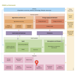
With this procedure, a change in soil properties (topsoil depth, soil depth, SOM in topsoil and subsoil, and soil texture) can be calculated as a result of land use and land cover. Subsequently, additional soil characteristics, such as water holding capacity and water infiltration rate, can be derived from these soil property values by using pedo-transfer functions ([[Van Beek, 2012]]). These soil characteristics can be used in other models in the IMAGE framework, such as [[LPJmL model|LPJmL]] (Component [[Carbon cycle and natural vegetation]] ) and [[GLOFRIS model|GLOFRIS]] (Component [[Flood risks]]), as alternative input to assess the consequences of historical or future land degradation. | With this procedure, a change in soil properties (topsoil depth, soil depth, SOM in topsoil and subsoil, and soil texture) can be calculated as a result of land use and land cover. Subsequently, additional soil characteristics, such as water holding capacity and water infiltration rate, can be derived from these soil property values by using pedo-transfer functions ([[Van Beek, 2012]]). These soil characteristics can be used in other models in the IMAGE framework, such as [[LPJmL model|LPJmL]] (Component [[Carbon cycle and natural vegetation]] ) and [[GLOFRIS model|GLOFRIS]] (Component [[Flood risks]]), as alternative input to assess the consequences of historical or future land degradation. | ||
|=1〗, the w∈ [0..1] and all values in the range [v_ls..v_hs ] are possible based on the landscape properties. Although in practice c is specific for each landscape property, soil type, and soil property, data are lacking to estimate c at that level of specificity. Therefore the model assumes that c is constant per soil and landscape property, or, in other words, the relative impact of landscape properties on a specific soil property is assumed to be constant over the different soil types. | |=1〗, the w∈ [0..1] and all values in the range [v_ls..v_hs ] are possible based on the landscape properties. Although in practice c is specific for each landscape property, soil type, and soil property, data are lacking to estimate c at that level of specificity. Therefore the model assumes that c is constant per soil and landscape property, or, in other words, the relative impact of landscape properties on a specific soil property is assumed to be constant over the different soil types. | ||
The soil properties are estimated based on land management and land use. This allows for the estimation of soil properties under pristine conditions. For future years, the NDVI map is changed as a function of land use, forest management and assumptions on degradation. To assess pristine conditions, soil properties are calculated with land use set at natural, and land cover represented by the NDVI under pristine conditions. | The soil properties are estimated based on land management and land use. This allows for the estimation of soil properties under pristine conditions. For future years, the NDVI map is changed as a function of land use, forest management and assumptions on degradation. To assess pristine conditions, soil properties are calculated with land use set at natural, and land cover represented by the NDVI under pristine conditions. | ||
With this procedure, a change in soil properties (topsoil depth, soil depth, SOM in topsoil and subsoil, and soil texture) can be calculated as a result of land use and land cover. Subsequently, additional soil characteristics, such as water holding capacity and water infiltration rate, can be derived from these soil property values by using pedo-transfer functions (Van Beek, 2012). These soil characteristics can be used in other models in the IMAGE framework, such as LPJmL (Section 6.1) and GLOFRIS (Section 7.4), as alternative input to assess the consequences of historical or future land degradation. | With this procedure, a change in soil properties (topsoil depth, soil depth, SOM in topsoil and subsoil, and soil texture) can be calculated as a result of land use and land cover. Subsequently, additional soil characteristics, such as water holding capacity and water infiltration rate, can be derived from these soil property values by using pedo-transfer functions (Van Beek, 2012). These soil characteristics can be used in other models in the IMAGE framework, such as LPJmL (Section 6.1) and GLOFRIS (Section 7.4), as alternative input to assess the consequences of historical or future land degradation. | ||
}} | }} | ||
Revision as of 13:06, 18 May 2014
Parts of Land degradation/Description
| Component is implemented in: |
|
| Related IMAGE components |
| Projects/Applications |
| Models/Databases |
| Key publications |
| References |