Water: Difference between revisions
No edit summary |
(minor textual corrections) |
||
| (63 intermediate revisions by 4 users not shown) | |||
| Line 1: | Line 1: | ||
{{ComponentTemplate2 | {{ComponentTemplate2 | ||
|Application=OECD Environmental Outlook to 2050 (2012) project | |||
|IMAGEComponent=Drivers;Agriculture and land use;Carbon, vegetation, agriculture and water;Carbon cycle and natural vegetation;Crops and grass;Human development;Energy demand;Land cover and land use;Land-use allocation;Livestock systems | |||
|KeyReference=Gerten et al., 2004;Biemans et al., 2011;Biemans, 2012;Schaphoff et al., 2018a;Bijl et al., 2016;Bijl et al., 2018a;Jägermeyr et al., 2015;De Vos et al., 2021 | |||
|Reference=OECD, 2012;Portmann et al., 2010;Fischer et al., 2005;Molden, 2007;FAO, 2011a;OECD, 2012 | |||
|InputVar=Land cover, land use - grid;Temperature - grid;Precipitation - grid;Crop irrigation water demand - grid;Crop irrigation water demand - grid;Irrigation system | |||
|Parameter=Soil properties - grid;Digital water network - grid;LOD (location of dams and reservoirs);Water demand other sectors - grid | |||
|OutputVar=River discharge - grid;Water withdrawal other sectors - grid;Irrigation water withdrawal - grid;Irrigation water consumption - grid;Water stress - basin;Number of people at risk of severe water stress - grid;Water consumption other sectors - grid;Environmental flow requirements - grid;Transgression of environmental flows - grid | |||
|ComponentCode=H | |ComponentCode=H | ||
| | |AggregatedComponent=Carbon, vegetation, agriculture and water | ||
|FrameworkElementType=state component | |FrameworkElementType=state component | ||
}} | |||
<div class="page_standard"> | |||
Water availability is essential for natural vegetation and agricultural production, human settlements and industry. Around one third of the world’s population lives in countries suffering from medium to high water stress ([[OECD, 2012]]). This number is expected to increase as the water demand will increase due to the population growth, and as water availability may decrease due to global warming. | |||
Today, agriculture accounts for 70% of the total global water withdrawals. Around one third of the total global crop production is irrigated, occupying 17% of croplands (e.g. [[Portmann et al., 2010]]). Irrigated agriculture is expected to increase further to meet the growing demand for food ([[Fischer et al., 2005]]; [[Molden, 2007]]; [[FAO, 2011a]]). Moreover, water demand in other sectors (domestic, electricity, manufacturing) is projected to increase substantially in the coming decades ([[OECD, 2012]]). As a result, competition between water users will increase and the resulting water shortages may affect future food production ([[Pastor et al., 2019]]; [[De Vos et al., 2021]]). | |||
}} | Although the global quantity of freshwater is more than sufficient to meet all human needs, uneven distribution makes water a scarce resource in some regions and watersheds. Furthermore, climate change will lead to changes in precipitation patterns, thus altering future water availability and adding to water stress in areas where precipitation levels are expected to decline. | ||
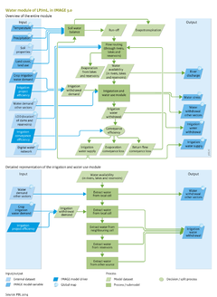
To identify current and future areas of water stress, IMAGE includes a hydrology model that calculates water availability and demand. The hydrological module of LPJmL is fully integrated with the terrestrial carbon and land-use dynamics of LPJmL and the rest of IMAGE and dynamically calculates agricultural water demand as well as water availability and withdrawals. Availability of renewable water is the net result of precipitation, interception loss and evapotranspiration by plants and soils. In the model, the surplus in each grid cell flows to neighbouring grid cells in a watershed by means of a river routing scheme. River flows are modified by dams and reservoirs used for irrigation and hydropower production. | |||
The effects of water stress on crop production can be quantified, and by including the feedback of water-limited crop production on land allocation, IMAGE can produce more realistic scenarios for cropland expansion and agricultural intensification. IMAGE and LPJmL are dynamically linked (see [[Carbon, vegetation, agriculture and water]]), and thus IMAGE scenarios include an integrated assessment of the water cycle and can be used to assess water availability and demand at high spatial (0.5x0.5 degree grid cells) and temporal (daily) resolutions. | |||
{{InputOutputParameterTemplate}} | |||
</div> | |||
Latest revision as of 18:02, 19 November 2021
| Component is implemented in: |
|
| Related IMAGE components |
| Projects/Applications |
| Key publications |
| References |
Key policy issues
- What is the combined effect of climate change and socio-economic development on water demand and availability, and on associated agricultural production?
- What is the potential of adaptation measures to reduce water stress and water-related crop production losses?
- How can water demand be reduced and still provide the adequate service levels to the sectors with the highest demand?
Introduction
Water availability is essential for natural vegetation and agricultural production, human settlements and industry. Around one third of the world’s population lives in countries suffering from medium to high water stress (OECD, 2012). This number is expected to increase as the water demand will increase due to the population growth, and as water availability may decrease due to global warming.
Today, agriculture accounts for 70% of the total global water withdrawals. Around one third of the total global crop production is irrigated, occupying 17% of croplands (e.g. Portmann et al., 2010). Irrigated agriculture is expected to increase further to meet the growing demand for food (Fischer et al., 2005; Molden, 2007; FAO, 2011a). Moreover, water demand in other sectors (domestic, electricity, manufacturing) is projected to increase substantially in the coming decades (OECD, 2012). As a result, competition between water users will increase and the resulting water shortages may affect future food production (Pastor et al., 2019; De Vos et al., 2021).
Although the global quantity of freshwater is more than sufficient to meet all human needs, uneven distribution makes water a scarce resource in some regions and watersheds. Furthermore, climate change will lead to changes in precipitation patterns, thus altering future water availability and adding to water stress in areas where precipitation levels are expected to decline.
To identify current and future areas of water stress, IMAGE includes a hydrology model that calculates water availability and demand. The hydrological module of LPJmL is fully integrated with the terrestrial carbon and land-use dynamics of LPJmL and the rest of IMAGE and dynamically calculates agricultural water demand as well as water availability and withdrawals. Availability of renewable water is the net result of precipitation, interception loss and evapotranspiration by plants and soils. In the model, the surplus in each grid cell flows to neighbouring grid cells in a watershed by means of a river routing scheme. River flows are modified by dams and reservoirs used for irrigation and hydropower production.
The effects of water stress on crop production can be quantified, and by including the feedback of water-limited crop production on land allocation, IMAGE can produce more realistic scenarios for cropland expansion and agricultural intensification. IMAGE and LPJmL are dynamically linked (see Carbon, vegetation, agriculture and water), and thus IMAGE scenarios include an integrated assessment of the water cycle and can be used to assess water availability and demand at high spatial (0.5x0.5 degree grid cells) and temporal (daily) resolutions.
Input/Output Table
Input Water component
| IMAGE model drivers and variables | Description | Source |
|---|---|---|
| Irrigation system | Type of irrigation system: surface, sprinkler or drip. This is allocated at country level, based on Jagermeyr et al (2015). | Drivers |
| Temperature - grid | Monthly average temperature. | Atmospheric composition and climate |
| Precipitation - grid | Monthly total precipitation. | Atmospheric composition and climate |
| Crop irrigation water demand - grid | Water requirements for crop irrigation, calculated as daily moisture deficit during the growing season. | Crops and grass |
| Land cover, land use - grid | Multi-dimensional map describing all aspects of land cover and land use per grid cell, such as type of natural vegetation, crop and grass fraction, crop management, fertiliser and manure input, livestock density. | Land cover and land use |
| External datasets | Description | Source |
|---|---|---|
| Digital water network - grid | Digital water network DDM30 describing drainage directions of surface water, with each cell only draining into one neighbouring cell, organising cells to river basins. | |
| LOD (location of dams and reservoirs) | Location, building year, purpose and size of 7000 largest reservoirs. | |
| Soil properties - grid | Soil properties that have an effect on vegetation growth and hydrology. These characteristics differ between soil types. Relevant characteristics are soil texture and depth and water holding capacity | HWSD database |
| Water demand other sectors - grid | Total annual water demand for non-agricultural sectors (households, industry and electricity production) |
Output Water component
| IMAGE model variables | Description | Use |
|---|---|---|
| River discharge - grid | Average flow of water through each grid cell. | |
| Water withdrawal other sectors - grid | Total annual and monthly water withdrawal for households, industry and electricity. Not necessarily equal to the withdrawal demand, due to limited water availability. | |
| Irrigation water withdrawal - grid | Water withdrawn for irrigation, not necessarily equal to the withdrawal demand, because of limited water availability in rivers, lakes, reservoirs and other sources. | |
| Number of people at risk of severe water stress - grid | Basins with ratios above 0.4 are considered to be severely water stressed. Using the projected population in each grid cell, the number of people at severe risk of water stress is determined | Final output |
| Water consumption other sectors - grid | Total annual and monthly water consumption for households, industry and electricity. Consumption is defined as the total withdrawals minus the return flows | Final output |
| Irrigation water consumption - grid | Water consumed through irrigation; equal to irrigation water withdrawal minus water lost during transport, depending on the conveyance efficiency. | Final output |
| Environmental flow requirements - grid | Percentage of natural flow reserved for the environment. Determined according to the Variable Monthly Flow method developed in Pastor et al., 2014 | Final output |
| Transgression of environmental flows - grid | Deficit on environmental flow requirements, based on monthly discharge values | Final output |
| Water stress - basin | Water stress is a basin scale indicator of the mean annual water demand to availability ratio. This ratio gives an indication for the level of water stress experienced in the basin. | Final output |