Welcome to IMAGE 3.2 Documentation and Plant functional types and natural land cover types: Difference between pages
(Difference between pages)
Jump to navigation
Jump to search
No edit summary |
Oostenrijr (talk | contribs) No edit summary |
||
| Line 1: | Line 1: | ||
__NOEDITSECTION__<div style="width: 35%;float: left"> | |||
'''LPJmL plant functional types (PFTs) ''' | |||
'''Tree PFTs:''' | |||
* Tropical (trop) | |||
** 1. tropical broad-leaved evergreen; | |||
** 2. tropical broad-leaved raingreen; | |||
* Temperate (tem) | |||
** 3. temperate needle-leaved evergreen; | |||
** 4. temperate broad-leaved evergreen; | |||
** 5. temperate broad-leaved summer green; | |||
* Boreal (bor) | |||
** 6. boreal summer green; | |||
** 7. boreal needle-leaved evergreen; | |||
'''Grass PFTs:''' | |||
* 8. C3 herbaceous;<br/> | |||
* 9. C4 herbaceous.</div><div style="width:35%";float: left> | |||
</div><div style="width: 35%;float: left"> | |||
'''IMAGE Natural land cover types (biomes)''' | |||
* Ice | |||
* Tundra | |||
* Wooded tundra | |||
* Boreal forest | |||
* Cool coniferous forest | |||
* Temperate mixed forest | |||
* Temperate deciduous forest | |||
* Warm mixed forest | |||
* Grassland and steppe | |||
* Hot desert | |||
* Scrubland | |||
* Savanna | |||
* Tropical woodland | |||
* Tropical forest | |||
</div> | |||
<div class="container"><div class="page_standard"> | |||
==Biome classification== | |||
Natural vegetation types (biomes) are classified based on the area shares of the plant functional types ({{AbbrTemplate|PFT}})s and their foliage projected cover (FPC); the mean temperature; and [[NPP (net primary production) - grid|net primary production (NPP)]] according to the flowchart below. | |||
</div></div> | |||
{{DisplayFigureLeftOptimalTemplate|PFT to NLCT}} | |||
[[Category:Glossary]] | |||
Latest revision as of 12:45, 17 May 2018
LPJmL plant functional types (PFTs)
Tree PFTs:
- Tropical (trop)
- 1. tropical broad-leaved evergreen;
- 2. tropical broad-leaved raingreen;
- Temperate (tem)
- 3. temperate needle-leaved evergreen;
- 4. temperate broad-leaved evergreen;
- 5. temperate broad-leaved summer green;
- Boreal (bor)
- 6. boreal summer green;
- 7. boreal needle-leaved evergreen;
Grass PFTs:
- 8. C3 herbaceous;
- 9. C4 herbaceous.
IMAGE Natural land cover types (biomes)
- Ice
- Tundra
- Wooded tundra
- Boreal forest
- Cool coniferous forest
- Temperate mixed forest
- Temperate deciduous forest
- Warm mixed forest
- Grassland and steppe
- Hot desert
- Scrubland
- Savanna
- Tropical woodland
- Tropical forest
Biome classification
Natural vegetation types (biomes) are classified based on the area shares of the plant functional types (PFT)s and their foliage projected cover (FPC); the mean temperature; and net primary production (NPP) according to the flowchart below.
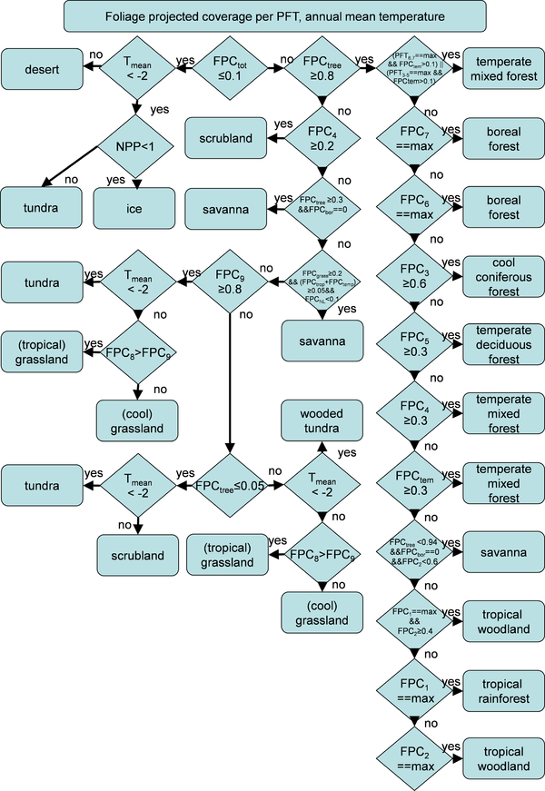
Natural land cover type (biome) classification from area shares of individual Plant Functional Types (PFT)s (expresses as foliage projected cover, FPC) and mean annual temperature (Tmean). Subscripts of FPC refer to individual PFTs (1: tropical broadleaved evergreen, 2: tropical broadleaved raingreen, 3: temperate needleleaved evergreen, 4: temperate broadleaved evergreen, 5: temperate broadleaved summergreen, 6: boreal summergreen, 7: boreal needleleaved evergreen, 8: C3 herbaceous, 9: C4 herbaceous), tropical PFTs (“trop”) are PFTs 1 and 2, temperate PFTs (“temp”) are PFTs 3-5, boreal PFTS (“bor”) are PFTs 6 and 7, tree PFTs (“tree”) are PFTs 1-7, grass PFTs are PFTs 8 and 9.