Flood risks: Difference between revisions
Jump to navigation
Jump to search
ArnoBouwman (talk | contribs) No edit summary |
ArnoBouwman (talk | contribs) No edit summary |
||
| Line 10: | Line 10: | ||
|Description=Flooding is the most frequent and costly natural hazard, affecting a majority of countries on a regular basis ([[UNISDR, 2011]]) ([[IPCC, 2012]]). Over the past few decades, the economic damage as a result of flooding has increased in most regions, primarily due to a growth in population and wealth in flood-prone areas ([[Bouwer et al., 2010]]; [[UNISDR, 2011]]; [[Barredo et al., 2012]]). | |Description=Flooding is the most frequent and costly natural hazard, affecting a majority of countries on a regular basis ([[UNISDR, 2011]]) ([[IPCC, 2012]]). Over the past few decades, the economic damage as a result of flooding has increased in most regions, primarily due to a growth in population and wealth in flood-prone areas ([[Bouwer et al., 2010]]; [[UNISDR, 2011]]; [[Barredo et al., 2012]]). | ||
The largest changes in economic loss and mortality from flooding are observed in developing countries, although data scarcities are hampering flood risk assessments. In order to evaluate current flood risk as well as possible changes under global change scenarios, there is a demand for rapid cost-effective assessments based on available global data sets. Such assessments are of interest to various users, for example, to international financing institutes for assessing which investments in natural disaster risk reduction would be the most promising; to national institutes for monitoring progress in risk reduction activities, such as those related to the implementation of the Hyogo Framework for Action ([[UNISDR, 2005]]); to insurance and reinsurance companies that need to justify their insurance coverage; and to a variety of large companies for assessing the risks related to regional investments. | The largest changes in economic loss and mortality from flooding are observed in developing countries, although data scarcities are hampering flood risk assessments. In order to evaluate current flood risk as well as possible changes under global change scenarios, there is a demand for rapid cost-effective assessments based on available global data sets. Such assessments are of interest to various users, for example, to international financing institutes for assessing which investments in natural disaster risk reduction would be the most promising; to national institutes for monitoring progress in risk reduction activities, such as those related to the implementation of the Hyogo Framework for Action ([[UNISDR, 2005]]); to insurance and reinsurance companies that need to justify their insurance coverage; and to a variety of large companies for assessing the risks related to regional investments. | ||
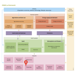
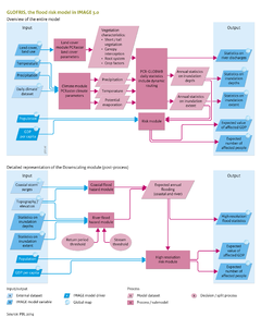
To meet this demand, the effect module ‘GLObal Flood Risks with IMAGE Scenarios’ (GLOFRIS) has been developed for IMAGE 3.0, in a joint effort, by [[Deltares]], [[PBL]] Netherlands Environmental Assessment Agency, Utrecht University ([[UU]]) and the Institute for Environmental Studies of VU University Amsterdam ([[IVM]]). The GLOFRIS model estimates the combination of river and coastal flood risks by integrating the global hydrological model [[PCR-GLOBWB model]] ([[Bierkens and Van Beek, 2009]]) and the global sea-level rise impacts model [[DIVA model]] ([[Hinkel and Klein, 2009]]), using climate scenario data from complex climate models and downscaled socioeconomic scenarios from [[IMAGE land use model]] . GLOFRIS may be used for assessing current and future flood risks related to climate, changing land-cover patterns and changing socioeconomic conditions for any world region. This can be done, globally, at a resolution of 0.5 x 0.5 degrees and, regionally, at a higher resolution (1 x 1 km<sup>2</sup>). The higher resolution is achieved using a specially developed downscaling algorithm and more detailed regional impact models. Impacts for several safety levels can be analysed. Possible applications include the preparation of IPCC scenarios for flood risk changes at 0.5 degree and 1 km<sup>2</sup> resolutions. | To meet this demand, the effect module ‘GLObal Flood Risks with IMAGE Scenarios’ (GLOFRIS) has been developed for IMAGE 3.0, in a joint effort, by [[Deltares]], [[PBL]] Netherlands Environmental Assessment Agency, Utrecht University ([[UU]]) and the Institute for Environmental Studies of VU University Amsterdam ([[IVM]]). The GLOFRIS model estimates the combination of river and coastal flood risks by integrating the global hydrological model [[PCR-GLOBWB model|PCR-GLOBWB]] ([[Bierkens and Van Beek, 2009]]) and the global sea-level rise impacts model [[DIVA model|DIVA]] ([[Hinkel and Klein, 2009]]), using climate scenario data from complex climate models and downscaled socioeconomic scenarios from [[IMAGE land use model|IMAGE]] . GLOFRIS may be used for assessing current and future flood risks related to climate, changing land-cover patterns and changing socioeconomic conditions for any world region. This can be done, globally, at a resolution of 0.5 x 0.5 degrees and, regionally, at a higher resolution (1 x 1 km<sup>2</sup>). The higher resolution is achieved using a specially developed downscaling algorithm and more detailed regional impact models. Impacts for several safety levels can be analysed. Possible applications include the preparation of IPCC scenarios for flood risk changes at 0.5 degree and 1 km<sup>2</sup> resolutions. | ||
}} | }} | ||
Revision as of 10:40, 9 December 2013
| Component is implemented in: |
|
| Related IMAGE components |
| Models/Databases |
| Key publications |
| References |
Key policy issues
- How will future flood risk change as a result of socio-economic changes and climate change?
- What would be the impact of floods, in terms of damage and victims, and where are the hot spots?
- What would be suitable adaptation strategies and investment options related to flood risk?