Flood risks/Policy issues: Difference between revisions
Jump to navigation
Jump to search
No edit summary |
ArnoBouwman (talk | contribs) No edit summary |
||
| Line 4: | Line 4: | ||
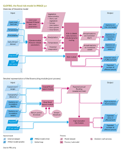
The study compares the current situation with the impacts of changes in climate and socioeconomic conditions. The left panel in the maps on the right shows the pattern of a flood occurring once every 30 years according to GLOFRIS, scaled down to 1 x 1 km<sup>2</sup> over Bangladesh, under current climate conditions. The right-hand panels in the maps on the right show the resulting expected values of damage under current climate and socioeconomic conditions, based on the two methods mentioned above. | The study compares the current situation with the impacts of changes in climate and socioeconomic conditions. The left panel in the maps on the right shows the pattern of a flood occurring once every 30 years according to GLOFRIS, scaled down to 1 x 1 km<sup>2</sup> over Bangladesh, under current climate conditions. The right-hand panels in the maps on the right show the resulting expected values of damage under current climate and socioeconomic conditions, based on the two methods mentioned above. | ||
Risk has been computed using these two methods for the reference situation and the two climate data sets. Under the current climate conditions, the projected annual damage in [[HasAcronym::GDP]] is around [[HasAcronym::USD]] 740 million, according to the land-use method (asset damage), and | Risk has been computed using these two methods for the reference situation and the two climate data sets. Under the current climate conditions, the projected annual damage in [[HasAcronym::GDP]] is around [[HasAcronym::USD]]2010 740 million, according to the land-use method (asset damage), and USD2010 2183 million using the population method (affected GDP). The graph on the right shows that under the scenarios of hazard and exposure changes, these values increase by a factor of 22 to 30 and 21 to 28, respectively, depending on the climate model used. The effects of simulated change in exposure only (increase by a factor of 11 and 7, respectively) were found to be much higher than those of climate change (increase by a factor of 3 to 4, depending on climate model and impact assessment method used). Calculations show that in the case of Bangladesh, the impacts of population and economic growth are much more important for future risks than the impacts of climate change. It will, therefore, be of interest to consider how the changes in socioeconomic conditions can be combined with a reduction in flood risk. | ||
|Example=To date, the model has not been used extensively to model specific policy interventions. Obviously, measures taken elsewhere in the IMAGE model to prevent climate change would reduce flood risks as well. | |Example=To date, the model has not been used extensively to model specific policy interventions. Obviously, measures taken elsewhere in the IMAGE model to prevent climate change would reduce flood risks as well. | ||
}} | }} | ||
Revision as of 10:18, 19 December 2013
Parts of Flood risks/Policy issues
| Component is implemented in: |
|
| Related IMAGE components |
| Models/Databases |
| Key publications |