Flood risks/Policy issues: Difference between revisions
Jump to navigation
Jump to search
ArnoBouwman (talk | contribs) No edit summary |
No edit summary |
||
| Line 2: | Line 2: | ||
|Status=On hold | |Status=On hold | ||
|Reference=Winsemius et al., 2012; | |Reference=Winsemius et al., 2012; | ||
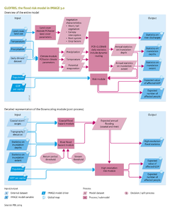
|Description=The GLOFRIS model can be used to assess a wide range of scenarios based on information on land cover and climate change. The model, for instance, has been applied to analyse the impact of floods on Bangladesh. This case study was published in Winsemius et al. ([[Winsemius et al., 2012]]) and is summarised below. | |Description=The [[GLOFRIS model]] can be used to assess a wide range of scenarios based on information on land cover and climate change. The model, for instance, has been applied to analyse the impact of floods on Bangladesh. This case study was published in Winsemius et al. ([[Winsemius et al., 2012]]) and is summarised below. | ||
The study compares the current situation with the impacts of changes in climate and socioeconomic conditions. The left panel in the maps on the right shows the pattern of a flood occurring once every 30 years according to GLOFRIS, scaled down to 1 x 1 km<sup>2</sup> over Bangladesh, under current climate conditions. The right-hand panels in the maps on the right show the resulting expected values of damage under current climate and socioeconomic conditions, based on the two methods mentioned above. | The study compares the current situation with the impacts of changes in climate and socioeconomic conditions. The left panel in the maps on the right shows the pattern of a flood occurring once every 30 years according to GLOFRIS, scaled down to 1 x 1 km<sup>2</sup> over Bangladesh, under current climate conditions. The right-hand panels in the maps on the right show the resulting expected values of damage under current climate and socioeconomic conditions, based on the two methods mentioned above. | ||
Revision as of 16:16, 10 December 2013
Parts of Flood risks/Policy issues
| Component is implemented in: |
|
| Related IMAGE components |
| Models/Databases |
| Key publications |