Flood risks/Data uncertainties limitations: Difference between revisions
Jump to navigation
Jump to search
No edit summary |
No edit summary |
||
| Line 1: | Line 1: | ||
{{ComponentDataUncertaintyAndLimitationsTemplate | {{ComponentDataUncertaintyAndLimitationsTemplate | ||
|Status=On hold | |Status=On hold | ||
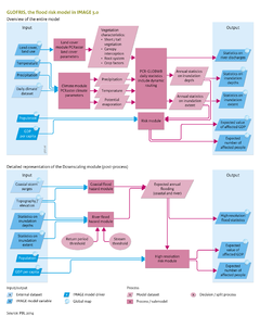
|Description=The most important external data are the digital elevation map, soil maps, initial land-use map, and a map of the global river network. Limitations and uncertainties in modelling future flood risks relate to model input and model parameterisation and processes included. | |Description=<h2>Data uncertainty and limitations</h2> | ||
The most important external data are the digital elevation map, soil maps, initial land-use map, and a map of the global river network. Limitations and uncertainties in modelling future flood risks relate to model input and model parameterisation and processes included. | |||
* The representativeness of the climate input is uncertain due to its limited sampling length (generally 30 years or 100 years) and uncertainty in climate models. A multi-model ensemble of projections, therefore, is highly recommended when preparing a scenario on future flood risk under a changed climate. | * The representativeness of the climate input is uncertain due to its limited sampling length (generally 30 years or 100 years) and uncertainty in climate models. A multi-model ensemble of projections, therefore, is highly recommended when preparing a scenario on future flood risk under a changed climate. | ||
Revision as of 11:58, 17 December 2013
Parts of Flood risks/Data uncertainties limitations
| Component is implemented in: |
|
| Related IMAGE components |
| Models/Databases |
| Key publications |