Flood risks/Data uncertainties limitations: Difference between revisions
Jump to navigation
Jump to search
m (Text replace - "DataAndLimitation" to "DataUncertaintyAndLimitation") |
ArnoBouwman (talk | contribs) No edit summary |
||
| Line 1: | Line 1: | ||
{{ComponentDataUncertaintyAndLimitationsTemplate | {{ComponentDataUncertaintyAndLimitationsTemplate | ||
|Status=On hold | |Status=On hold | ||
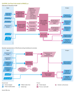
|Reference=Winsemius et al., 2012 | |||
|Description=The most important external data are the digital elevation map, soil maps, initial land-use map, and a map of the global river network. Limitations and uncertainties in modelling future flood risks relate to model input and model parameterisation and processes included. | |||
* The representativeness of the climate input is uncertain due to its limited sampling length (generally 30 years or 100 years) and uncertainty in climate models. A multi-model ensemble of projections, therefore, is highly recommended when preparing a scenario on future flood risk under a changed climate. | |||
* The [[PCR-GLOBWB model|PCR-GLOBWB]] hydrological model has uncertainties in its parameterisation of soils, vegetation, flood plain dimensions and roughness. This uncertainty is inherent to any hydrological model, and may be estimated by using a multi-model ensemble built from runs with several hydrological models, suitable for estimating flood hazards. This is a subject for future study. | |||
* The downscaling algorithm is sensitive to the elevation model used and the choice of relevant rivers and flood return periods (see also [[Winsemius et al., 2012]]). This uncertainty is particularly relevant when computing the flood risk of low return period events. Under high return periods, the bankfull volume becomes relatively small compared to the total flood volume and therefore less important. The uncertainty of the chosen bankfull volume relates to the following uncertainty. In areas with high protection standards (e.g. against 100-, 500- or 1000-year floods), the simulated time series are likely to be too short to establish a satisfying probability distribution of events. Therefore, the applicability of our framework, to date, has been limited to areas with low protection standards. This is the case in most developing countries. | |||
* Man-made interactions with river systems, such as the operation of dams and reservoirs, have not yet been taken into account. Instead, reservoirs are simulated as natural lakes with a free overflow. These could be included in future studies, but with the risk of incorrectly estimating reservoir operation during flood conditions. The impact of reservoir control could result in a reduction in floods if the controller has proper information at hand to decide on pre-releases, but in many cases if such information is not available, this may result in larger floods due to unexpected inflows of water. Therefore, to date, no reservoir management has been considered in GLOFRIS. | |||
* The effect of levee breaches also has not been included. This can have large impacts on flood patterns. For example, during the Pakistan floods of 2009, a large part of a major embankment was destroyed by the floods, causing a completely different flood pattern than would be simulated by any model under the assumption of levee overtopping as the only flood mechanism. If the user is interested in this type of flood mechanisms, a more interactive approach to mapping flood hazard is required, which would allow for ‘what if’ scenarios on the schematisation of the elevation profile within a case study area. Obviously, such ‘what if’ scenarios are not suited for a global approach, such as presented here. | |||
* Relatively simple stage-damage functions are used to estimate risks related to flood hazard and exposure. These functions vary greatly across the globe and may even represent the largest absolute uncertainty in our model results. | |||
* Flood risk is modelled as a function of flood hazard, exposure, and vulnerability, with vulnerability being assumed to remain the same over time and space. However, future developments in resilience and adaptation measures may reduce vulnerability (e.g. due to increased awareness, other building methods or flood warning procedures). | |||
}} | }} | ||
Revision as of 14:06, 9 December 2013
Parts of Flood risks/Data uncertainties limitations
| Component is implemented in: |
|
| Related IMAGE components |
| Models/Databases |
| Key publications |