Flood risks/Data uncertainties limitations: Difference between revisions
Jump to navigation
Jump to search
No edit summary |
No edit summary |
||
| Line 1: | Line 1: | ||
{{ComponentDataUncertaintyAndLimitationsTemplate | {{ComponentDataUncertaintyAndLimitationsTemplate | ||
|Status=On hold | |Status=On hold | ||
|Reference=Winsemius et al., 2012 | |Reference=Winsemius et al., 2012; Ward et al., 2013; | ||
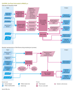
|Description=The most important external data are the digital elevation map, soil maps, initial land-use map, and a map of the global river network. Limitations and uncertainties in modelling future flood risks relate to model input and model parameterisation and processes included. | |Description=The most important external data are the digital elevation map, soil maps, initial land-use map, and a map of the global river network. Limitations and uncertainties in modelling future flood risks relate to model input and model parameterisation and processes included. | ||
Revision as of 11:07, 11 December 2013
Parts of Flood risks/Data uncertainties limitations
| Component is implemented in: |
|
| Related IMAGE components |
| Models/Databases |
| Key publications |