IMAGE framework/IMAGE 3.0 in a nutshell: Difference between revisions
Jump to navigation
Jump to search
Oostenrijr (talk | contribs) m (Text replace - "IMAGE framework scheme" to "IMAGE framework schematic") |
Oostenrijr (talk | contribs) No edit summary |
||
| Line 65: | Line 65: | ||
While IMAGE is designed to address global issues, impacts and challenges tend to occur at different geographic scales and to different degrees in different parts of the world. This depends on location-specific biophysical conditions, and on the level of human development (for example high income, industrialised versus low income, subsistence agriculture dominated regions, and all levels in between). It implies that indicators at the level of global totals or global averages are rarely adequate to reveal the real problems. Furthermore, policy interventions and governance structures are not uniform across scales and administrative entities, and are bound by cultural and political history. | While IMAGE is designed to address global issues, impacts and challenges tend to occur at different geographic scales and to different degrees in different parts of the world. This depends on location-specific biophysical conditions, and on the level of human development (for example high income, industrialised versus low income, subsistence agriculture dominated regions, and all levels in between). It implies that indicators at the level of global totals or global averages are rarely adequate to reveal the real problems. Furthermore, policy interventions and governance structures are not uniform across scales and administrative entities, and are bound by cultural and political history. | ||
To capture spatial and multi-scale differences, IMAGE models socio-economic developments in 26 world regions (see | To capture spatial and multi-scale differences, IMAGE models socio-economic developments in 26 world regions (see the figure on the right). Land use, land cover, and associated biophysical processes are treated at grid level to capture local dynamics. The grid size has been reduced to 5 x 5 arcminutes in IMAGE 3.0 (corresponding to 10 x 10 km at the equator), from 30 x 30 arcminutes (0.5 x 0.5 degrees) in IMAGE 2. Operating within global boundaries, the regional approach provides insight to identify where specific problems manifest, where the driving factors are concentrated, and how changes in some regions influence other regions. | ||
===Areas of application=== | ===Areas of application=== | ||
| Line 76: | Line 76: | ||
Over the years, various components of the IMAGE framework have been replaced by expert models developed outside IMAGE, which be used either as stand-alone models or within the IMAGE framework (see [[Computer models overview]]) . | Over the years, various components of the IMAGE framework have been replaced by expert models developed outside IMAGE, which be used either as stand-alone models or within the IMAGE framework (see [[Computer models overview]]) . | ||
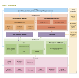
The IMAGE 3.0 core model comprises most processes in the Human system, the Earth system and their connectors Land cover/Land use and Emissions, and parts of the impacts (see | The IMAGE 3.0 core model comprises most processes in the Human system, the Earth system and their connectors Land cover/Land use and Emissions, and parts of the impacts (see the figure on the right). This core model consists of IMAGE/TIMER energy and IMAGE/Land & Climate. The latter also includes the LPJmL model, which is an essential component of any IMAGE model run, representing carbon, water, crop and vegetation dynamics. | ||
The IMAGE 3.0 framework contains other models that are employed to generate impacts (such as, [[GLOBIO model|GLOBIO]], [[GLOFRIS model|GLOFRIS]] and [[GISMO model|GISMO]]), and models that describe parts of the Human system, such as agro-economic models ([[MAGNET model|MAGNET]] and [[IMPACT model|IMPACT]]) to project future agricultural production requirements. Furthermore, policy models, such as [[FAIR model|FAIR]], are used in exploring effectiveness, efficiency and equity of climate policy regimes, and to provide input on emission constraints and price signals arising from climate policy proposals. | The IMAGE 3.0 framework contains other models that are employed to generate impacts (such as, [[GLOBIO model|GLOBIO]], [[GLOFRIS model|GLOFRIS]] and [[GISMO model|GISMO]]), and models that describe parts of the Human system, such as agro-economic models ([[MAGNET model|MAGNET]] and [[IMPACT model|IMPACT]]) to project future agricultural production requirements. Furthermore, policy models, such as [[FAIR model|FAIR]], are used in exploring effectiveness, efficiency and equity of climate policy regimes, and to provide input on emission constraints and price signals arising from climate policy proposals. | ||
Revision as of 09:15, 24 June 2014
| Projects/Applications |
| Models/Databases |
| Relevant overviews |