IMAGE framework summary/Interaction: Difference between revisions
Jump to navigation
Jump to search
m (Text replace - "Agricultural systems" to "Land-use allocation") |
m (Text replace - "Land cover and use" to "Land cover and land use") |
||
| Line 8: | Line 8: | ||
===Land cover and land use === | ===Land cover and land use === | ||
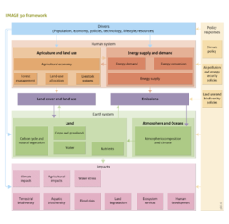
Using demand for agricultural products, including food, feed and bioenergy, the Land-use allocation model locates production areas on a 5 x 5 minute grid (Component [[Land-use allocation]]). A region-specific regression based suitability assessment and an iterative allocation procedure are used. Alternatively, the land-use model can also integrate CLUMondo (using a more complex allocation procedure). In most regions, the main determinants of suitability for agricultural expansion are population density, accessibility, topography, and agricultural productivity. In the model, suitability is used in combination with regional preferences for different types of production systems (determined from historical calibration) to allocate land use to the grid. In addition, the IMAGE land use and land cover module (Component [[Land cover and use]]) collects and combines information from the agricultural system and the Earth system to provide maps of land-use and land-cover parameters, including fertiliser input, livestock densities, rain-fed and irrigated crop fractions, bioenergy crops, and forest management. | Using demand for agricultural products, including food, feed and bioenergy, the Land-use allocation model locates production areas on a 5 x 5 minute grid (Component [[Land-use allocation]]). A region-specific regression based suitability assessment and an iterative allocation procedure are used. Alternatively, the land-use model can also integrate CLUMondo (using a more complex allocation procedure). In most regions, the main determinants of suitability for agricultural expansion are population density, accessibility, topography, and agricultural productivity. In the model, suitability is used in combination with regional preferences for different types of production systems (determined from historical calibration) to allocate land use to the grid. In addition, the IMAGE land use and land cover module (Component [[Land cover and land use]]) collects and combines information from the agricultural system and the Earth system to provide maps of land-use and land-cover parameters, including fertiliser input, livestock densities, rain-fed and irrigated crop fractions, bioenergy crops, and forest management. | ||
<BlockQuote> | <BlockQuote> | ||
Revision as of 18:28, 16 May 2014
| Projects/Applications |
| Relevant overviews |
| Key publications |