IMAGE framework/IMAGE 3.0 in a nutshell: Difference between revisions
Jump to navigation
Jump to search
No edit summary |
No edit summary |
||
| Line 18: | Line 18: | ||
Traditionally, IMAGE has strived to be comprehensive in terms of human activities, sectors and environmental problems and where and how these are connected through common drivers, through mutual impacts and through synergy and trade-off. In this sense IMAGE differs from other [[IAM]] models, that are for the most part rooted in the energy-economy-climate nexus and have expanded their coverage only more recently to issues of land-use and land-cover change, water availability and other broader sustainable development issues. | Traditionally, IMAGE has strived to be comprehensive in terms of human activities, sectors and environmental problems and where and how these are connected through common drivers, through mutual impacts and through synergy and trade-off. In this sense IMAGE differs from other [[IAM]] models, that are for the most part rooted in the energy-economy-climate nexus and have expanded their coverage only more recently to issues of land-use and land-cover change, water availability and other broader sustainable development issues. | ||
As described in [[ | As described in [[Scenario drivers]], future pathways or scenarios depend critically on assumed projections of key driving forces. Hence all results can only be understood and interpreted properly in the context of the assumed future environment in which they unfold. | ||
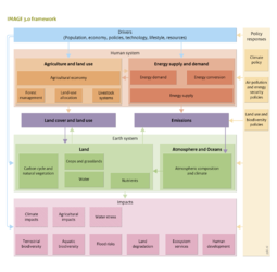
The figure below illustrates how the various subsystems of the overall IMAGE framework are put together, showing the flow of information from the key driving factors to the impact indicators. As the diagram shows, it projects how human activities would develop in the box Socio-economic System as a result of a suite of exogenous drivers; see the box Scenario drivers and [[ | The figure below illustrates how the various subsystems of the overall IMAGE framework are put together, showing the flow of information from the key driving factors to the impact indicators. As the diagram shows, it projects how human activities would develop in the box Socio-economic System as a result of a suite of exogenous drivers; see the box Scenario drivers and [[Scenario drivers]]. The human activities and the associated demands for goods and services are squared with the Earth System through the ‘interconnectors’ [[Land cover and land use]], and [[Emissions]]. Assumed policy interventions lead to model responses, taking all internal interactions and feedback into account; see the rightmost box. Impacts in various forms arise either directly from the model itself, for example the extent of future land-use for agriculture, forestry, etc.; or the average global temperature rise until the year 2050. Other indicators are generated by invoking additional models that use output from the core IMAGE model, together with other relevant assumptions to estimate the effects. For example biodiversity ([[GLOBIO model|GLOBIO]]; see [[Aquatic biodiversity]]) or [[Flood risks]]. Obviously, impacts emerging from such additional models do not influence the outcome of the model run directly. But the results found can reveal unsustainable or otherwise undesirable impacts, and induce exploration of alternative model assumptions aiming to alleviate the problem found. As the alternative is again implemented in the coupled set of models, the synergies with or trade-offs against other indicators are revealed. | ||
| Line 37: | Line 37: | ||
While an integrated framework such as IMAGE contains, and must contain, variables in many different domains, looking at applications and areas where development work has concentrated, it is appropriate to say that the model framework focusses on two main clusters: | While an integrated framework such as IMAGE contains, and must contain, variables in many different domains, looking at applications and areas where development work has concentrated, it is appropriate to say that the model framework focusses on two main clusters: | ||
# Energy and climate | |||
# Food, land, water and forestry | |||
It must be noted, that many relations exist in IMAGE between these two clusters. To name a few: climate change impacts on agriculture and nature, land for bio-energy with implications for food prices, water for irrigation competing with water as coolant for electric power plants, and many more. In fact, these mutual relations, synergies and trade-offs are typically most interesting from the perspective of policy discussions that face the complicating effect of unintended but often undesirable impacts on other concerns than the issue for which they aim to find solutions. For that purpose it is extremely helpful that IMAGE 3.0 has the capacity to generate a long and widely diverging set of indicators, relevant for different sectors and regions. | It must be noted, that many relations exist in IMAGE between these two clusters. To name a few: climate change impacts on agriculture and nature, land for bio-energy with implications for food prices, water for irrigation competing with water as coolant for electric power plants, and many more. In fact, these mutual relations, synergies and trade-offs are typically most interesting from the perspective of policy discussions that face the complicating effect of unintended but often undesirable impacts on other concerns than the issue for which they aim to find solutions. For that purpose it is extremely helpful that IMAGE 3.0 has the capacity to generate a long and widely diverging set of indicators, relevant for different sectors and regions. | ||
In order to avoid possible confusion it is good to realize that on the one hand there exists an IMAGE 3.0 core model, comprising (almost all) processes mentioned in the boxes Socio-economic system, Earth system and their connectors Landcover/Land-use and Emissions, and parts of the impacts. In practice this consists of two pieces of model code: IMAGE/[[TIMER model|TIMER]] energy and IMAGE/Land&Climate. As mentioned, a suite of other models is additionally available to generate impacts. But also to provide input to the socio-economic system, such as agro-economic models to project future agricultural production requirements. Furthermore, policy models such as [[FAIR model|FAIR]] play an important role in exploring effectiveness, efficiency and equity aspects of future climate policy regimes, and provide input on emissions constraints and price signals arising from climate policy proposals. That wider set is commonly referred to as the MAGE 3.0 framework . | In order to avoid possible confusion it is good to realize that on the one hand there exists an IMAGE 3.0 core model, comprising (almost all) processes mentioned in the boxes Socio-economic system, Earth system and their connectors Landcover/Land-use and Emissions, and parts of the impacts. In practice this consists of two pieces of model code: IMAGE/[[TIMER model|TIMER]] energy and IMAGE/Land&Climate. As mentioned, a suite of other models is additionally available to generate impacts. But also to provide input to the socio-economic system, such as agro-economic models to project future agricultural production requirements. Furthermore, policy models such as [[FAIR model|FAIR]] play an important role in exploring effectiveness, efficiency and equity aspects of future climate policy regimes, and provide input on emissions constraints and price signals arising from climate policy proposals. That wider set is commonly referred to as the MAGE 3.0 framework . | ||
To apply the IMAGE 3.0 model for a specific purpose, what is needed is of course the model with all endogenous settings and data so that it reproduces the relevant aspects of the state-of-the-world in the year 2005. In fact, the state in the year 2005 is calculated by the model over the period starting in 1970, using exogenous data to calibrate internal parameters. From 2005 onwards, a range of model drivers, rooted in more generic scenario drivers, must be prepared either by experts or teams at PBL, or by working together with other partners supplying inputs such as population, economic projections and food production. For more information on drivers, see [[ | To apply the IMAGE 3.0 model for a specific purpose, what is needed is of course the model with all endogenous settings and data so that it reproduces the relevant aspects of the state-of-the-world in the year 2005. In fact, the state in the year 2005 is calculated by the model over the period starting in 1970, using exogenous data to calibrate internal parameters. From 2005 onwards, a range of model drivers, rooted in more generic scenario drivers, must be prepared either by experts or teams at PBL, or by working together with other partners supplying inputs such as population, economic projections and food production. For more information on drivers, see [[Scenario drivers]]. Of course, all this typically done in consultation with stakeholders and sponsors of the studies, and with project partners. | ||
As will be illustrated by the [[Chapter 4 through 8]], an IMAGE run produces a very long list of output representing the results of the various parts of the framework, either as end-indicator or as intermediate deliveries driving operations further downstream. Together the outputs span the range from drivers to pressures, states and finally impacts. Outputs from the IMAGE 3.0 core model concern energy use, conversion and supply; agricultural production; land cover and land-use; nutrient cycles in natural and agricultural systems; emissions to air and surface water; carbon stocks in biomass pools, soils, atmosphere and oceans; atmospheric emissions of greenhouse gases and air pollutants; concentration of greenhouse gases in the atmosphere and radiative forcing; changes in temperature and precipitation; sea level rise; water use for irrigation; and many others. The additional impact models complement these ‘standard’ outputs with biodiversity indicators; human development indicators; water stress; flood risks; and others. | As will be illustrated by the [[Chapter 4 through 8]], an IMAGE run produces a very long list of output representing the results of the various parts of the framework, either as end-indicator or as intermediate deliveries driving operations further downstream. Together the outputs span the range from drivers to pressures, states and finally impacts. Outputs from the IMAGE 3.0 core model concern energy use, conversion and supply; agricultural production; land cover and land-use; nutrient cycles in natural and agricultural systems; emissions to air and surface water; carbon stocks in biomass pools, soils, atmosphere and oceans; atmospheric emissions of greenhouse gases and air pollutants; concentration of greenhouse gases in the atmosphere and radiative forcing; changes in temperature and precipitation; sea level rise; water use for irrigation; and many others. The additional impact models complement these ‘standard’ outputs with biodiversity indicators; human development indicators; water stress; flood risks; and others. | ||
}} | }} | ||
Revision as of 11:54, 12 December 2013
Parts of IMAGE framework/IMAGE 3.0 in a nutshell
| Projects/Applications |
| Models/Databases |
| Relevant overviews |