Land degradation/Description: Difference between revisions
Jump to navigation
Jump to search
No edit summary |
No edit summary |
||
| Line 79: | Line 79: | ||
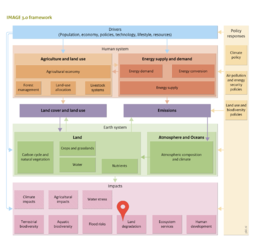
Land cover is characterised by a remotely sensed {{abbrTemplate|NDVI}} map. The soil property v at location x with soil s is estimated as | Land cover is characterised by a remotely sensed {{abbrTemplate|NDVI}} map. The soil property v at location x with soil s is estimated as | ||
{{ | {{DisplayFigureLeftOptimalTemplate|Formula1 LD|plain}} | ||
with w<sub>x </sub>being a weight w∈ [0..1] that determines where v is in the range [v<sub>ls</sub>..v<sub>hs</sub> ]. Different explanatory factors represented by the landscape properties determine w. The weight at location x is calculated as | with w<sub>x </sub>being a weight w∈ [0..1] that determines where v is in the range [v<sub>ls</sub>..v<sub>hs</sub> ]. Different explanatory factors represented by the landscape properties determine w. The weight at location x is calculated as | ||
Revision as of 12:00, 19 May 2014
Parts of Land degradation/Description
| Component is implemented in: |
|
| Related IMAGE components |
| Projects/Applications |
| Models/Databases |
| Key publications |
| References |