Land degradation/Policy issues: Difference between revisions
Jump to navigation
Jump to search
Oostenrijr (talk | contribs) No edit summary |
Oostenrijr (talk | contribs) No edit summary |
||
| Line 1: | Line 1: | ||
{{ComponentPolicyIssueTemplate | {{ComponentPolicyIssueTemplate | ||
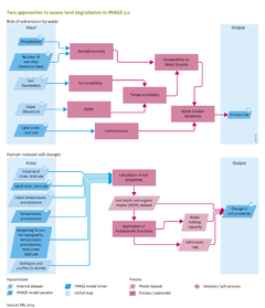
|Description=The land degradation model in its current state is used to explore changes in degradation risk over time. Module A for Water Erosion Sensitivity is used to assess risks of soil erosion by water. Resulting maps are used to identify the most sensitive regions, and how areas under different risk categories change over time and space, subject to scenarios of future land use and climate change ( | |Description=The land degradation model in its current state is used to explore changes in degradation risk over time. Module A for Water Erosion Sensitivity is used to assess risks of soil erosion by water. Resulting maps are used to identify the most sensitive regions, and how areas under different risk categories change over time and space, subject to scenarios of future land use and climate change (the Baseline figure below). | ||
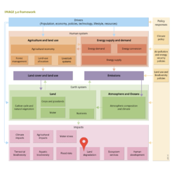
Module B for Human-Induced Soil Changes is used to estimate how historical land degradation propagates through the IMAGE 3.0 framework via change in topsoil depth, soil organic matter content and hydrologic soil properties. As a result of changing soil properties, agricultural productivity calculated by the [[LPJmL model]] can change (Figure Policy interventions). This module is used for future projections to assess the effect of climate change , land-use change, land cover change (as vegetation cover), and restoration activities on soil properties, and to study the impact of these changes on crop production, hydrology, and land-use dynamics. | Module B for Human-Induced Soil Changes is used to estimate how historical land degradation propagates through the IMAGE 3.0 framework via change in topsoil depth, soil organic matter content and hydrologic soil properties. As a result of changing soil properties, agricultural productivity calculated by the [[LPJmL model]] can change (Figure Policy interventions). This module is used for future projections to assess the effect of climate change , land-use change, land cover change (as vegetation cover), and restoration activities on soil properties, and to study the impact of these changes on crop production, hydrology, and land-use dynamics. | ||
Revision as of 14:57, 30 June 2014
Parts of Land degradation/Policy issues
| Component is implemented in: |
|
| Related IMAGE components |
| Projects/Applications |
| Models/Databases |
| Key publications |