Crops and grass/Data uncertainties limitations: Difference between revisions
Jump to navigation
Jump to search
No edit summary |
No edit summary |
||
| Line 1: | Line 1: | ||
{{ComponentDataUncertaintyAndLimitationsTemplate | {{ComponentDataUncertaintyAndLimitationsTemplate | ||
|Reference=Rosenzweig et al., 2013; | |Reference=Rosenzweig et al., 2013; | ||
|Description=<h2>Data, uncertainties and limitations</h2> | |Description=<h2>Data, uncertainties and limitations</h2> | ||
===Uncertainties=== | ===Uncertainties=== | ||
| Line 11: | Line 11: | ||
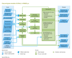
LPJmL has been shown to be capable of reproducing agricultural water and carbon fluxes and pools for several sites (Bondeau et al., 2007). However, projections of global yield patterns are difficult to evaluate because of the strong management signal that is currently not represented at the process base in the model. | LPJmL has been shown to be capable of reproducing agricultural water and carbon fluxes and pools for several sites (Bondeau et al., 2007). However, projections of global yield patterns are difficult to evaluate because of the strong management signal that is currently not represented at the process base in the model. | ||
Initial results from comparison of the global gridded crop models (joint activity of the Agricultural Model Inter-comparison and Improvement Project | Initial results from comparison of the global gridded crop models (joint activity of the Agricultural Model Inter-comparison and Improvement Project and the Inter-Sectoral Impact Model Inter-comparison ([[AgMIP and ISI-MIP project]])) indicate that LPJmL results are within the range of other model projections, but are on the optimistic end for effectiveness of CO2 fertilisation ([[Rosenzweig et al., 2013]]). | ||
===Limitations=== | ===Limitations=== | ||
| Line 19: | Line 19: | ||
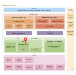
Land-use data from IMAGE available on a 5 minute spatial resolution are aggregated to the 30 minute resolution of LPJmL. Higher spatial resolution in the simulation of agricultural productivity would allow for more flexibility in land-use allocation, but is currently prohibited by computational requirements and the resolution of the river routing scheme in the hydrology module (section [[Water]]). | Land-use data from IMAGE available on a 5 minute spatial resolution are aggregated to the 30 minute resolution of LPJmL. Higher spatial resolution in the simulation of agricultural productivity would allow for more flexibility in land-use allocation, but is currently prohibited by computational requirements and the resolution of the river routing scheme in the hydrology module (section [[Water]]). | ||
}} | }} | ||
Revision as of 14:12, 20 May 2014
Parts of Crops and grass/Data uncertainties limitations
| Component is implemented in: |
|
| Related IMAGE components |
| Projects/Applications |
| Key publications |
| References |