IMAGE framework/A brief history of IMAGE: Difference between revisions
Jump to navigation
Jump to search
No edit summary |
No edit summary |
||
| Line 2: | Line 2: | ||
|ExternalModel=LPJmL model; MAGICC model; GLOBIO model | |ExternalModel=LPJmL model; MAGICC model; GLOBIO model | ||
|Reference=Alcamo, 1994; Rotmans, 1990; Alcamo et al., 1998; IMAGE-team, 2001; MNP, 2006; | |Reference=Alcamo, 1994; Rotmans, 1990; Alcamo et al., 1998; IMAGE-team, 2001; MNP, 2006; | ||
|Description= | |Description===A brief history of IMAGE== | ||
IMAGE 3.0 is the most recent, operational model framework progressively developed since in 1980s. Over the years the model was enhanced and extended continuously through incremental changes, and more profound revisions. | IMAGE 3.0 is the most recent, operational model framework progressively developed since in 1980s. Over the years the model was enhanced and extended continuously through incremental changes, and more profound revisions. | ||
==IMAGE 1.0== | ===IMAGE 1.0=== | ||
IMAGE 1.0 ([[Rotmans, 1990]]) was developed as a single region, integrated global model to explore interactions between human activities and future climate change. As one of the first Integrated Assessment Models to address climate change, IMAGE contributed to raising awareness of the long-term consequences of human development. In the absence of regional or spatially explicit algorithms, the model operated on trends in global total and average parameters, such as world population and averaged emission factors per unit of activity. | IMAGE 1.0 ([[Rotmans, 1990]]) was developed as a single region, integrated global model to explore interactions between human activities and future climate change. As one of the first Integrated Assessment Models to address climate change, IMAGE contributed to raising awareness of the long-term consequences of human development. In the absence of regional or spatially explicit algorithms, the model operated on trends in global total and average parameters, such as world population and averaged emission factors per unit of activity. | ||
==IMAGE 2.0 to 2.2== | ===IMAGE 2.0 to 2.2=== | ||
In the 1990s, the new generation IMAGE 2, was developed with regional drivers of global change and gridded, process-oriented modelling of the terrestrial biosphere, land cover and land use ([[Alcamo, 1994]]). IMAGE 2.0 comprised three subsystems: | In the 1990s, the new generation IMAGE 2, was developed with regional drivers of global change and gridded, process-oriented modelling of the terrestrial biosphere, land cover and land use ([[Alcamo, 1994]]). IMAGE 2.0 comprised three subsystems: | ||
* 13-region Energy-Industry System (EIS); | * 13-region Energy-Industry System (EIS); | ||
| Line 18: | Line 18: | ||
The enhanced capabilities of IMAGE 2.2 were demonstrated in the contribution to the IPCC Special Report on Emissions Scenarios ([[IMAGE-team, 2001]]). The earlier zonal-mean climate-ocean model was replaced by a combination of the [[MAGICC model|MAGICC]] climate model and the Bern ocean model. The resulting global average temperature and precipitation changes were scaled using temperature and precipitation patterns generated by complex Global Circulation Models ({{abbrTemplate|GCM}}s) to provide spatially explicit climate impacts and feedback. For economy and energy, the EIS of version 2.0 was replaced with the TIMER energy model, which also improved linkage with the macroeconomic model Worldscan. | The enhanced capabilities of IMAGE 2.2 were demonstrated in the contribution to the IPCC Special Report on Emissions Scenarios ([[IMAGE-team, 2001]]). The earlier zonal-mean climate-ocean model was replaced by a combination of the [[MAGICC model|MAGICC]] climate model and the Bern ocean model. The resulting global average temperature and precipitation changes were scaled using temperature and precipitation patterns generated by complex Global Circulation Models ({{abbrTemplate|GCM}}s) to provide spatially explicit climate impacts and feedback. For economy and energy, the EIS of version 2.0 was replaced with the TIMER energy model, which also improved linkage with the macroeconomic model Worldscan. | ||
==IMAGE 2.4== | ===IMAGE 2.4=== | ||
A range of developments were implemented stepwise in intermediate versions, leading to the release of IMAGE 2.4 ([[MNP, 2006]]). In close cooperation with the agro-economic research institute [[LEI]], links were established with agro-economic modelling in IMAGE 2.4. This ensured the inclusion of biophysical conditions in modelling future agricultural production based on intensification of production and expansion of agricultural area. | A range of developments were implemented stepwise in intermediate versions, leading to the release of IMAGE 2.4 ([[MNP, 2006]]). In close cooperation with the agro-economic research institute [[LEI]], links were established with agro-economic modelling in IMAGE 2.4. This ensured the inclusion of biophysical conditions in modelling future agricultural production based on intensification of production and expansion of agricultural area. | ||
| Line 25: | Line 25: | ||
Many of the modules were enhanced, including the energy model TIMER, emission modelling and the carbon cycle. Experimental links with an intermediate complexity climate model were discontinued and the simple climate model [[MAGICC model|MAGICC]] with a strong feature to represent uncertainties in the climate system was adopted as the default. IMAGE 2.4 has played a key role in supporting various international environmental assessment studies. | Many of the modules were enhanced, including the energy model TIMER, emission modelling and the carbon cycle. Experimental links with an intermediate complexity climate model were discontinued and the simple climate model [[MAGICC model|MAGICC]] with a strong feature to represent uncertainties in the climate system was adopted as the default. IMAGE 2.4 has played a key role in supporting various international environmental assessment studies. | ||
==Towards IMAGE 3.0== | ===Towards IMAGE 3.0=== | ||
After publication of the IMAGE 2.4 book and a subsequent progress review by the IMAGE Advisory Board, the framework has been further developed. These developments were published in journal articles and conference papers, but no new versions were officially released. For example, representation of energy demand was improved by more bottom-up modelling of household energy systems in TIMER for rural and urban population by income level. Selected industries were better represented in more technical detail to underpin energy demands and emissions. The forestry sector included forestry management options in addition to clear-cutting. | After publication of the IMAGE 2.4 book and a subsequent progress review by the IMAGE Advisory Board, the framework has been further developed. These developments were published in journal articles and conference papers, but no new versions were officially released. For example, representation of energy demand was improved by more bottom-up modelling of household energy systems in TIMER for rural and urban population by income level. Selected industries were better represented in more technical detail to underpin energy demands and emissions. The forestry sector included forestry management options in addition to clear-cutting. | ||
In cooperation with Wageningen University ([[Wageningen UR|WUR]]) and the Potsdam Institute for Climate Impact Research ([[PIK]], Germany), the IMAGE natural vegetation and crop modules were replaced with the [[LPJmL model|LPJmL]] Global Dynamic Vegetation Model. This enabled modelling of linked carbon and water cycles, and adding a global hydrology module to IMAGE, which was not available in previous versions. Modelling biodiversity impacts was extended to cover freshwater systems as well as terrestrial biomes. | In cooperation with Wageningen University ([[Wageningen UR|WUR]]) and the Potsdam Institute for Climate Impact Research ([[PIK]], Germany), the IMAGE natural vegetation and crop modules were replaced with the [[LPJmL model|LPJmL]] Global Dynamic Vegetation Model. This enabled modelling of linked carbon and water cycles, and adding a global hydrology module to IMAGE, which was not available in previous versions. Modelling biodiversity impacts was extended to cover freshwater systems as well as terrestrial biomes. | ||
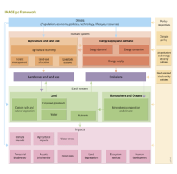
==IMAGE 3.0== | ===IMAGE 3.0=== | ||
The following new developments have been incorporated in IMAGE 3.0: | The following new developments have been incorporated in IMAGE 3.0: | ||
Revision as of 09:06, 24 May 2014
| Projects/Applications |
| Models/Databases |
| Relevant overviews |
| References |