Land-use allocation: Difference between revisions
Jump to navigation
Jump to search
Oostenrijr (talk | contribs) No edit summary |
No edit summary |
||
| Line 10: | Line 10: | ||
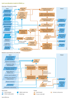
The location of new agricultural area determines the vegetation type removed, and thus the amount of carbon emitted, and the biodiversity impacts related to a loss of the vegetation type. Extreme examples of location-specific impacts are conversion of carbon- and species-rich peatland and wetlands. Other factors include the impact of agriculture on nutrient and water cycles, and location characteristics such as soil properties and slope. As well as the location, the composition of landscapes is a determining factor because how land uses are connected determines to some extent the environmental impact and the production potential. For environmental impacts, the most prominent examples of landscape composition are biodiversity effects, wind and water erosion, hydrology, and ecosystem services. Some crops benefit from nearby forests for pollination and pest control, while others suffer additional pest pressure. Consequently, accurate and high resolution modelling of agricultural land use is essential in global integrated assessment. | The location of new agricultural area determines the vegetation type removed, and thus the amount of carbon emitted, and the biodiversity impacts related to a loss of the vegetation type. Extreme examples of location-specific impacts are conversion of carbon- and species-rich peatland and wetlands. Other factors include the impact of agriculture on nutrient and water cycles, and location characteristics such as soil properties and slope. As well as the location, the composition of landscapes is a determining factor because how land uses are connected determines to some extent the environmental impact and the production potential. For environmental impacts, the most prominent examples of landscape composition are biodiversity effects, wind and water erosion, hydrology, and ecosystem services. Some crops benefit from nearby forests for pollination and pest control, while others suffer additional pest pressure. Consequently, accurate and high resolution modelling of agricultural land use is essential in global integrated assessment. | ||
In IMAGE, the spatial allocation of crops, pasture and bioenergy is driven by regional crop and grassland production and their respective intensity levels, as calculated by the the IMAGE agro-economic model ([[Agricultural economy]]), by the potential crop and grass yields ([[Crops and grass]]), and suitability factors | In IMAGE, the spatial allocation of crops, pasture and bioenergy is driven by regional crop and grassland production and their respective intensity levels, as calculated by the the IMAGE agro-economic model ([[Agricultural economy]]), by the potential crop and grass yields ([[Crops and grass]]), and spatial allocation suitability factors. | ||
|ComponentCode=AS | |ComponentCode=AS | ||
|AggregatedComponent=Agriculture and land use | |AggregatedComponent=Agriculture and land use | ||
|FrameworkElementType=pressure component | |FrameworkElementType=pressure component | ||
}} | }} | ||
Revision as of 13:24, 4 November 2016
Parts of Land-use allocation
| Component is implemented in: |
| Components: |
| Related IMAGE components |
| Projects/Applications |
| Key publications |
| References |
Key policy issues
- How will changes in agricultural demand and trade affect future land-use patterns?
- How will land-use regulation, such as protected areas and REDD schemes, affect future land use and the impacts of land-use change?
- How can agricultural intensification increase global food production, and what policies will contribute to this?