Land-use allocation/Description: Difference between revisions
Jump to navigation
Jump to search
No edit summary |
No edit summary |
||
| Line 21: | Line 21: | ||
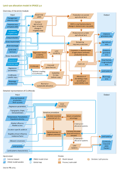
Land-use change is determined by various factors, such as climate and climate variability, soil and terrain characteristics, and socio-economic variables, such as population density and accessibility ([[O'Neill, 2013]]). Land-use change dynamics differ substantially between regions ([[Lambin et al., 2000]]). These characteristics are taken into account in IMAGE 3.0 in a regional suitability assessment based on an empirical multiple linear regression analysis. | Land-use change is determined by various factors, such as climate and climate variability, soil and terrain characteristics, and socio-economic variables, such as population density and accessibility ([[O'Neill, 2013]]). Land-use change dynamics differ substantially between regions ([[Lambin et al., 2000]]). These characteristics are taken into account in IMAGE 3.0 in a regional suitability assessment based on an empirical multiple linear regression analysis. | ||
The suitability assessment includes data on two biophysical determinants: the potential yield which covers effects of climate and soil ([[Crop and grass]]), and [[Slope - grid|the terrain slope index]] based on {{TempAcronymTemplate| | The suitability assessment includes data on two biophysical determinants: the potential yield which covers effects of climate and soil ([[Crop and grass]]), and [[Slope - grid|the terrain slope index]] based on {{TempAcronymTemplate|SRTM}} elevation data (Shuttle Radar Topography Mission) from NASA. Two socio-economic determinants are included: population density ([[Klein Goldewijk et al., 2010]]), and the accessibility index from JRC ([[Nelson, 2008]]), which is defined as minutes travel time to major cities (>50,000 inhabitants). | ||
These four independent variables are used in multiple linear regression analysis to investigate the relationship between these land-use determinants and current land use (fractions of crop and grassland in 2005 from [[Klein Goldewijk et al., 2011]]). The analysis is performed separately for each IMAGE region, and takes into account the logarithmic relationship found for all independent variables except for potential crop yield. | These four independent variables are used in multiple linear regression analysis to investigate the relationship between these land-use determinants and current land use (fractions of crop and grassland in 2005 from [[Klein Goldewijk et al., 2011]]). The analysis is performed separately for each IMAGE region, and takes into account the logarithmic relationship found for all independent variables except for potential crop yield. | ||
Revision as of 14:55, 5 May 2014
Parts of Land-use allocation/Description
| Component is implemented in: |
| Components: |
| Related IMAGE components |
| Projects/Applications |
| Key publications |
| References |