Land-use allocation/Description: Difference between revisions
Jump to navigation
Jump to search
m (Text replace - "Livestock" to "Livestock systems") |
m (Text replace - "Land cover and use" to "Land cover and land use") |
||
| Line 17: | Line 17: | ||
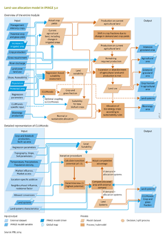
In agricultural areas, the fraction of specific crops is determined based on the initial fractions, and modified annually based on changes in regional demand and local crop yields. As a result, the land-use fraction of a certain crop increases when the demand for this crop increases faster than for other crops, or if the potential yield in this grid cell increases more than for other crops. | In agricultural areas, the fraction of specific crops is determined based on the initial fractions, and modified annually based on changes in regional demand and local crop yields. As a result, the land-use fraction of a certain crop increases when the demand for this crop increases faster than for other crops, or if the potential yield in this grid cell increases more than for other crops. | ||
The land use allocation model enables new land-use and land cover maps to be created ([[Land cover and use]]). These land-use maps specify agricultural land, extensive grassland, and, land for sustainable bioenergy production. Crop fractions are allocated for all 18 crop types in IMAGE (temperate cereals, rice, maize, tropical cereals, roots and tubers, pulses, and oil crops, both rain-fed and irrigated; grass: and sugar cane, maize for bioenergy and woody and non-woody bioenergy). These data are calculated on a 5 minute resolution, and aggregated to proportional land use on 30 minute resolution of the carbon, crop and water model [[LPJmL model|LPJmL]]. Additional data layers are provided when linked to CLUMondo (see [[#CLUMondo|below]]). | The land use allocation model enables new land-use and land cover maps to be created ([[Land cover and land use]]). These land-use maps specify agricultural land, extensive grassland, and, land for sustainable bioenergy production. Crop fractions are allocated for all 18 crop types in IMAGE (temperate cereals, rice, maize, tropical cereals, roots and tubers, pulses, and oil crops, both rain-fed and irrigated; grass: and sugar cane, maize for bioenergy and woody and non-woody bioenergy). These data are calculated on a 5 minute resolution, and aggregated to proportional land use on 30 minute resolution of the carbon, crop and water model [[LPJmL model|LPJmL]]. Additional data layers are provided when linked to CLUMondo (see [[#CLUMondo|below]]). | ||
==Empirical regression analysis to determine land use suitability== | ==Empirical regression analysis to determine land use suitability== | ||
Revision as of 19:28, 16 May 2014
Parts of Land-use allocation/Description
| Component is implemented in: |
| Components: |
| Related IMAGE components |
| Projects/Applications |
| Key publications |
| References |